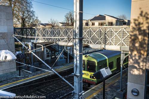
"I'm sitting in the railway station," sang Paul Simon.
I noticed that the sign at the entrance said "Malahide Train Station" and there was me referring to them as "Railway Stations" for the last sixty years.
According to the Google Books Ngram Viewer, which calculates the frequency of phrases in all books scanned by Google from 1800 to 2000, the phrase "train station" was first used significantly in 1960, and has been growing in popularity ever since. However, at least according to Google's data, "railway station" is still more popular.
Thursday, January 10, 2013
Malahide Railway Station (or should I say "Train station"?)
Friday, December 28, 2012
Tram Watch In Dublin
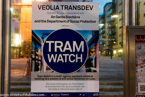
I use the red line service on a daily basis and almost every day I witness some form of anti-social behaviour.
"Over the years Dublin City has seen an increase in incidents of anti- social behaviour. The public including those who use public transport often talk about these incidents and what can be done. Luas being an integral part of the city has also seen a rise in incidents of anti- social behaviour and we are intent on tackling this problem to ensure that your journey remains as seamless and enjoyable as possible."
"To this end we have adopted an approach to the matter and call this Tram Watch."
"Tram Watch is a multi-agency approach bringing together several departments of Veolia Transdev, Luas security provider STT, An Garda Síochána and the Department of Social Protection to ensure all Luas passengers have a valid ticket or social welfare travel pass and that no-one behaving in an anti-social manner is allowed on-board the trams or on Luas infrastructure."
Thursday, December 20, 2012
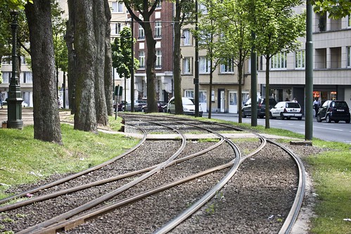
Brussels Tram (Video Clip)
Brussels Tram (Video Clip) a video by infomatique on Flickr.
There are 17 routes, serving most points of the compass, and including two partial ring routes. These have a very varied feel, including street running through narrow streets in working class districts (lines 81 and 82), cobbled central reservation, reserved track through parkland and woods (44), and signal-controlled running in tunnels (the "premetro"). There are even some short stretches of gutter running (18). Almost all trams are double-ended and all are double-sided, and some stub termini in the middle of the road remain (55), although most have loops. The route pattern shows some notable gaps, particularly along major radial routes, because these were originally served by a separate tram system, the national network of tramways vicinaux/buurtspoorwegen. These had a track gauge of one metre, as against the Brussels standard gauge, and so the tracks could not easily be taken over when the lines were progressively closed from the 1960s onwards.
The complementary routing of vicinal and urban tracks and the replacement of key lines by metro has led to some peculiar track layouts, for instance at the Barrière de St-Gilles/Bareel St-Gillis. Of the seven roads that meet at this circular junction, six originally contained tramlines, whereas today only three do. To negotiate a sharp turn, route 18, until it was closed on 1 July 2007, had to make a 270-degree turn on its journey away from the city centre, looping round and crossing its own path.
A further peculiarity is that under the South station, the premetro and metro tracks both swap from running on the right to running on the left where they run parallel to provide cross-platform interchange between the two lines. This serves no apparent purpose, but may be because main line trains in Belgium run on the left. The metro returns to running on the right under the new Jacques Brel depot.
Between 2006 and 2009 a phased transformation of the tram network took place, with the aim of improving regularity and relieving overcrowding. As part of this the premetro service between North station and Albert was restructured with fewer lines passing through it, but at more regular intervals. These routes use the new longer Bombardier trams. During this period of transformation the bus network underwent complementary revisions.

The Brussels Tram System
Intermodal integration
The system exists in an interesting local government context, because Brussels is a self-governing region, in fact an enclave within Flanders, although lying only some 3.3 kilometres from Wallonia at the closest point. This means that three-way deals are necessary between Brussels’ own STIB/MIVB, Flanders’ De Lijn and Wallonia’s TEC. Within the range of transport modes operated by STIB/MIVB (the Brussels Intercommunal Transport Company) trams fall between buses and a heavy metro. But beyond that, STIB sees itself as a provider of mobility rather than just public transport, and has a 49% share in the town’s Cambio car sharing franchise.
The Brussels conurbation – its 19 municipalities plus adjoining commuter belt – is also served by a fairly dense network of main-line trains. There is a good level of interticketing, and multiple-journey cards are interchangeable. A simple tariff system permits passengers to make unlimited changes with a one-hour period at a cost of €2.50 when bought from the driver or €2.00 when bought from a ticket machine.
Ridership has been rising, and other user-friendly features that have grown up through custom and practice help this. For instance passengers open the doors themselves by pressing a green strip on the central pole, and drivers usually make a point of waiting for latecomers. However overcrowding at rush hours and at weekend is common, and fare-dodging is reputedly quite high, despite periodic enforcement campaigns.
Brussels Tram System: History
The first horse-drawn trams were introduced in Brussels in 1869, and ran from the Porte de Namur to the Bois de la Cambre.
Brussels - Tram system (Route 19)
The tram route 19 in Brussels, Belgium is a tram route operated by the STIB/MIVB, which connects the Flemish town of Groot-Bijgaarden in the municipality of Dilbeek to the De Wand stop in Laeken in the municipality of the City of Brussels.
Starting from the Groot-Bijgaarden railway station in Dilbeek, the route then stops at the Bayens roundabout and then enters the Brussels-Capital Region via the Brusselstraat. The first stop in Brussels is at Hunderenveld in the municipality of Sint-Agatha-Berchem. The route then runs along the Avenue du Roi Albert/Koning Albertlaan up to the Dr. Schweitzer square, the Avenue Josse Goffin/Josse Goffinlaan and the Avenue de l'Hôpital Français/Frans Gasthuislaan where it enters the municipality of Koekelberg. The route then runs along the Basilica of the Sacred Heart and the Elisabeth park on the Avenue du Panthéon/Pantheonlaan and then on the Avenue de la Liberté/Vrijheidslaan up to the Simonis metro station. At Simonis the route turns left on the Avenue de Jette/Jetselaan and then enters the municipality of Jette. At the Queen Astrid square the route heads towards the Jette railway station via the Rue Léon Théodor/Léon Théodorstraat, then runs around the Jette cemetary via the Rue Jules Lahaye/Jules Lahayestraat and enters the Boulevard de Smet de Naeyer/De Smet de Naeyerlaan. Further on this boulevard, the route enters the borough of Laeken in the City of Brussels and then connects again with the Brussels Metro at the Stuyvenbergh metro station. The route finally runs along the Avenue des Robiniers/Witte Acacialaan and Avenue Jean Sobieski/Jan Sobieskilaan and then crosses the Laeken park by entering a tunnel which ends at the other end of the Laeken park at the De Wand stop.
Starting from the Groot-Bijgaarden railway station in Dilbeek, the route then stops at the Bayens roundabout and then enters the Brussels-Capital Region via the Brusselstraat. The first stop in Brussels is at Hunderenveld in the municipality of Sint-Agatha-Berchem. The route then runs along the Avenue du Roi Albert/Koning Albertlaan up to the Dr. Schweitzer square, the Avenue Josse Goffin/Josse Goffinlaan and the Avenue de l'Hôpital Français/Frans Gasthuislaan where it enters the municipality of Koekelberg. The route then runs along the Basilica of the Sacred Heart and the Elisabeth park on the Avenue du Panthéon/Pantheonlaan and then on the Avenue de la Liberté/Vrijheidslaan up to the Simonis metro station. At Simonis the route turns left on the Avenue de Jette/Jetselaan and then enters the municipality of Jette. At the Queen Astrid square the route heads towards the Jette railway station via the Rue Léon Théodor/Léon Théodorstraat, then runs around the Jette cemetary via the Rue Jules Lahaye/Jules Lahayestraat and enters the Boulevard de Smet de Naeyer/De Smet de Naeyerlaan. Further on this boulevard, the route enters the borough of Laeken in the City of Brussels and then connects again with the Brussels Metro at the Stuyvenbergh metro station. The route finally runs along the Avenue des Robiniers/Witte Acacialaan and Avenue Jean Sobieski/Jan Sobieskilaan and then crosses the Laeken park by entering a tunnel which ends at the other end of the Laeken park at the De Wand stop.
Subscribe to:
Posts (Atom)