The tram route 19 in Brussels, Belgium is a tram route operated by the STIB/MIVB, which connects the Flemish town of Groot-Bijgaarden in the municipality of Dilbeek to the De Wand stop in Laeken in the municipality of the City of Brussels.
Starting from the Groot-Bijgaarden railway station in Dilbeek, the route then stops at the Bayens roundabout and then enters the Brussels-Capital Region via the Brusselstraat. The first stop in Brussels is at Hunderenveld in the municipality of Sint-Agatha-Berchem. The route then runs along the Avenue du Roi Albert/Koning Albertlaan up to the Dr. Schweitzer square, the Avenue Josse Goffin/Josse Goffinlaan and the Avenue de l'Hôpital Français/Frans Gasthuislaan where it enters the municipality of Koekelberg. The route then runs along the Basilica of the Sacred Heart and the Elisabeth park on the Avenue du Panthéon/Pantheonlaan and then on the Avenue de la Liberté/Vrijheidslaan up to the Simonis metro station. At Simonis the route turns left on the Avenue de Jette/Jetselaan and then enters the municipality of Jette. At the Queen Astrid square the route heads towards the Jette railway station via the Rue Léon Théodor/Léon Théodorstraat, then runs around the Jette cemetary via the Rue Jules Lahaye/Jules Lahayestraat and enters the Boulevard de Smet de Naeyer/De Smet de Naeyerlaan. Further on this boulevard, the route enters the borough of Laeken in the City of Brussels and then connects again with the Brussels Metro at the Stuyvenbergh metro station. The route finally runs along the Avenue des Robiniers/Witte Acacialaan and Avenue Jean Sobieski/Jan Sobieskilaan and then crosses the Laeken park by entering a tunnel which ends at the other end of the Laeken park at the De Wand stop.
Showing posts with label Photographed By William Murphy. Show all posts
Showing posts with label Photographed By William Murphy. Show all posts
Thursday, December 20, 2012

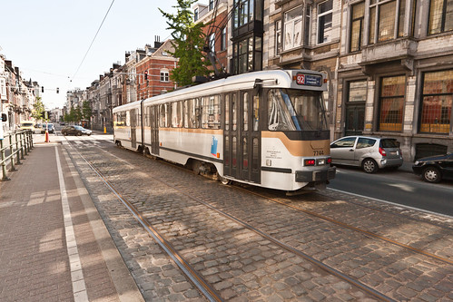
No. 92 Tram - Brussels
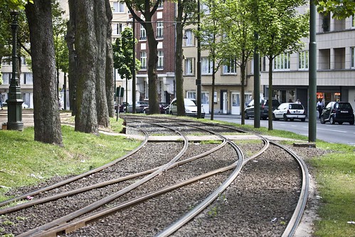
There are 17 routes, serving most points of the compass, and including two partial ring routes. These have a very varied feel, including street running through narrow streets in working class districts (lines 81 and 82), cobbled central reservation, reserved track through parkland and woods (44), and signal-controlled running in tunnels (the "premetro"). There are even some short stretches of gutter running (18). Almost all trams are double-ended and all are double-sided, and some stub termini remain (4, 55), although most have loops. The route pattern shows some notable gaps, particularly along major radial routes, because these were originally served by a separate tram system, the national network of buurtspoorwegen/tramways vicinaux. These had a track gauge of one metre, as against the Brussels standard gauge, and so the tracks could not easily be taken over when the lines were progressively closed from the 1960s onwards.
The complementary routing of vicinal and urban tracks and the replacement of key lines by metro has led to some peculiar track layouts, for instance at the Barrière de St-Gilles/Bareel St-Gillis. Of the seven roads that meet at this circular junction, all originally contained tramlines, whereas today only three do. To negotiate a sharp turn, route 18, until it was closed on 1 July 2007, had to make a 270-degree turn on its journey away from the city centre, looping round and crossing its own path.
A further peculiarity is that under the South station, the premetro and metro tracks both swap from running on the right to running on the left where they run parallel to provide cross-platform interchange between the two lines. This serves no apparent purpose, but may be because main line trains in Belgium run on the left. The metro returns to running on the right under the new Jacques Brel depot.
Between 2006 and 2009 a phased transformation of the tram network took place, with the aim of improving regularity and relieving overcrowding. As part of this the premetro service between North station and Albert was restructured with fewer lines passing through it, but at more regular intervals. These routes use the new longer Bombardier trams. The major part of the North-South Axis (from Lemonnier to Rogier) is now only used by lines 3 and 4 during the day. Tram lines 55 and 56 from Schaerbeek (north of Brussels) that used to ride the North-South Axis now stop at Rogier and nearby Gare du Nord/Noordstation.
As part of that plan, line 52 has been replaced by line 3 in the North (from the Brussels-South railway station to Thomas and from Van Praet to Esplanade), and by lines 56 (from Rogier to Princess Elisabeth), 82 (from Drogenbos to Lemonnier) and 32 in the South.
An already implemented part of this plan is the creation of tramway lines 24 and 25. Since April 2007 the new line 25 goes from Rogier to the Boondael/Boondaal railway station following the route of the ex-line 90 from Rogier to Buyl, then leaves the outer ring towards the Université Libre de Bruxelles campus of Solbosch. The (somewhat older) new line 24 strengthens the tram presence on the outer ring during daytime; it goes from the Schaerbeek/Schaarbeek railway station to Vanderkindere in Uccle.
en.wikipedia.org/wiki/Brussels_trams
The complementary routing of vicinal and urban tracks and the replacement of key lines by metro has led to some peculiar track layouts, for instance at the Barrière de St-Gilles/Bareel St-Gillis. Of the seven roads that meet at this circular junction, all originally contained tramlines, whereas today only three do. To negotiate a sharp turn, route 18, until it was closed on 1 July 2007, had to make a 270-degree turn on its journey away from the city centre, looping round and crossing its own path.
A further peculiarity is that under the South station, the premetro and metro tracks both swap from running on the right to running on the left where they run parallel to provide cross-platform interchange between the two lines. This serves no apparent purpose, but may be because main line trains in Belgium run on the left. The metro returns to running on the right under the new Jacques Brel depot.
Between 2006 and 2009 a phased transformation of the tram network took place, with the aim of improving regularity and relieving overcrowding. As part of this the premetro service between North station and Albert was restructured with fewer lines passing through it, but at more regular intervals. These routes use the new longer Bombardier trams. The major part of the North-South Axis (from Lemonnier to Rogier) is now only used by lines 3 and 4 during the day. Tram lines 55 and 56 from Schaerbeek (north of Brussels) that used to ride the North-South Axis now stop at Rogier and nearby Gare du Nord/Noordstation.
As part of that plan, line 52 has been replaced by line 3 in the North (from the Brussels-South railway station to Thomas and from Van Praet to Esplanade), and by lines 56 (from Rogier to Princess Elisabeth), 82 (from Drogenbos to Lemonnier) and 32 in the South.
An already implemented part of this plan is the creation of tramway lines 24 and 25. Since April 2007 the new line 25 goes from Rogier to the Boondael/Boondaal railway station following the route of the ex-line 90 from Rogier to Buyl, then leaves the outer ring towards the Université Libre de Bruxelles campus of Solbosch. The (somewhat older) new line 24 strengthens the tram presence on the outer ring during daytime; it goes from the Schaerbeek/Schaarbeek railway station to Vanderkindere in Uccle.
en.wikipedia.org/wiki/Brussels_trams
Subscribe to:
Posts (Atom)