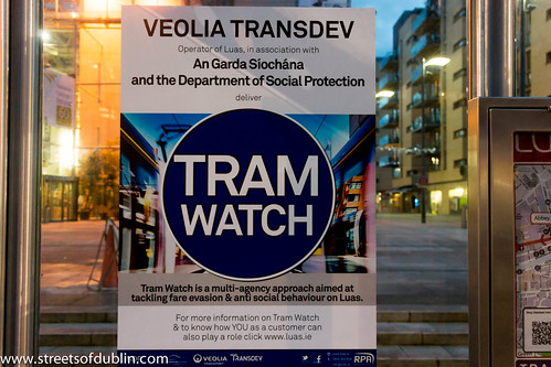
I use the red line service on a daily basis and almost every day I witness some form of anti-social behaviour.
"Over the years Dublin City has seen an increase in incidents of anti- social behaviour. The public including those who use public transport often talk about these incidents and what can be done. Luas being an integral part of the city has also seen a rise in incidents of anti- social behaviour and we are intent on tackling this problem to ensure that your journey remains as seamless and enjoyable as possible."
"To this end we have adopted an approach to the matter and call this Tram Watch."
"Tram Watch is a multi-agency approach bringing together several departments of Veolia Transdev, Luas security provider STT, An Garda Síochána and the Department of Social Protection to ensure all Luas passengers have a valid ticket or social welfare travel pass and that no-one behaving in an anti-social manner is allowed on-board the trams or on Luas infrastructure."
Friday, December 28, 2012
Tram Watch In Dublin
Thursday, December 20, 2012
Brussels Tram (Video Clip)
Brussels Tram (Video Clip) a video by infomatique on Flickr.
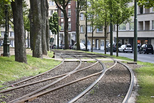
There are 17 routes, serving most points of the compass, and including two partial ring routes. These have a very varied feel, including street running through narrow streets in working class districts (lines 81 and 82), cobbled central reservation, reserved track through parkland and woods (44), and signal-controlled running in tunnels (the "premetro"). There are even some short stretches of gutter running (18). Almost all trams are double-ended and all are double-sided, and some stub termini in the middle of the road remain (55), although most have loops. The route pattern shows some notable gaps, particularly along major radial routes, because these were originally served by a separate tram system, the national network of tramways vicinaux/buurtspoorwegen. These had a track gauge of one metre, as against the Brussels standard gauge, and so the tracks could not easily be taken over when the lines were progressively closed from the 1960s onwards.
The complementary routing of vicinal and urban tracks and the replacement of key lines by metro has led to some peculiar track layouts, for instance at the Barrière de St-Gilles/Bareel St-Gillis. Of the seven roads that meet at this circular junction, six originally contained tramlines, whereas today only three do. To negotiate a sharp turn, route 18, until it was closed on 1 July 2007, had to make a 270-degree turn on its journey away from the city centre, looping round and crossing its own path.
A further peculiarity is that under the South station, the premetro and metro tracks both swap from running on the right to running on the left where they run parallel to provide cross-platform interchange between the two lines. This serves no apparent purpose, but may be because main line trains in Belgium run on the left. The metro returns to running on the right under the new Jacques Brel depot.
Between 2006 and 2009 a phased transformation of the tram network took place, with the aim of improving regularity and relieving overcrowding. As part of this the premetro service between North station and Albert was restructured with fewer lines passing through it, but at more regular intervals. These routes use the new longer Bombardier trams. During this period of transformation the bus network underwent complementary revisions.

The Brussels Tram System
Intermodal integration
Brussels Tram System: History
Brussels - Tram system (Route 19)
Starting from the Groot-Bijgaarden railway station in Dilbeek, the route then stops at the Bayens roundabout and then enters the Brussels-Capital Region via the Brusselstraat. The first stop in Brussels is at Hunderenveld in the municipality of Sint-Agatha-Berchem. The route then runs along the Avenue du Roi Albert/Koning Albertlaan up to the Dr. Schweitzer square, the Avenue Josse Goffin/Josse Goffinlaan and the Avenue de l'Hôpital Français/Frans Gasthuislaan where it enters the municipality of Koekelberg. The route then runs along the Basilica of the Sacred Heart and the Elisabeth park on the Avenue du Panthéon/Pantheonlaan and then on the Avenue de la Liberté/Vrijheidslaan up to the Simonis metro station. At Simonis the route turns left on the Avenue de Jette/Jetselaan and then enters the municipality of Jette. At the Queen Astrid square the route heads towards the Jette railway station via the Rue Léon Théodor/Léon Théodorstraat, then runs around the Jette cemetary via the Rue Jules Lahaye/Jules Lahayestraat and enters the Boulevard de Smet de Naeyer/De Smet de Naeyerlaan. Further on this boulevard, the route enters the borough of Laeken in the City of Brussels and then connects again with the Brussels Metro at the Stuyvenbergh metro station. The route finally runs along the Avenue des Robiniers/Witte Acacialaan and Avenue Jean Sobieski/Jan Sobieskilaan and then crosses the Laeken park by entering a tunnel which ends at the other end of the Laeken park at the De Wand stop.
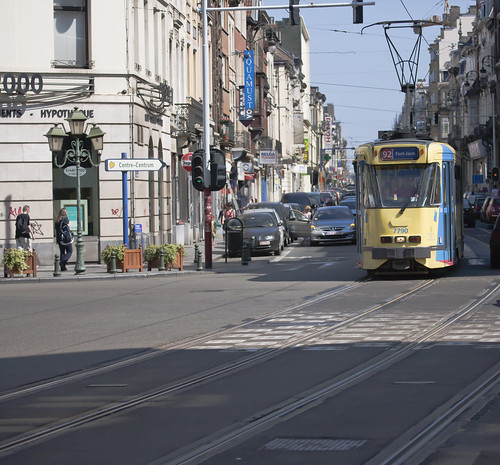
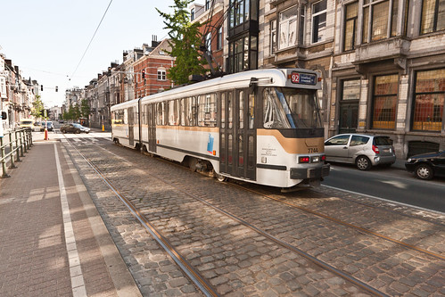
Brussels - The 92 Tram
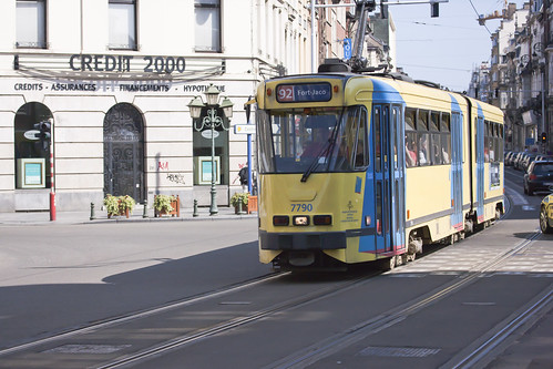
No. 92 Tram - Brussels
The complementary routing of vicinal and urban tracks and the replacement of key lines by metro has led to some peculiar track layouts, for instance at the Barrière de St-Gilles/Bareel St-Gillis. Of the seven roads that meet at this circular junction, all originally contained tramlines, whereas today only three do. To negotiate a sharp turn, route 18, until it was closed on 1 July 2007, had to make a 270-degree turn on its journey away from the city centre, looping round and crossing its own path.
A further peculiarity is that under the South station, the premetro and metro tracks both swap from running on the right to running on the left where they run parallel to provide cross-platform interchange between the two lines. This serves no apparent purpose, but may be because main line trains in Belgium run on the left. The metro returns to running on the right under the new Jacques Brel depot.
Between 2006 and 2009 a phased transformation of the tram network took place, with the aim of improving regularity and relieving overcrowding. As part of this the premetro service between North station and Albert was restructured with fewer lines passing through it, but at more regular intervals. These routes use the new longer Bombardier trams. The major part of the North-South Axis (from Lemonnier to Rogier) is now only used by lines 3 and 4 during the day. Tram lines 55 and 56 from Schaerbeek (north of Brussels) that used to ride the North-South Axis now stop at Rogier and nearby Gare du Nord/Noordstation.
As part of that plan, line 52 has been replaced by line 3 in the North (from the Brussels-South railway station to Thomas and from Van Praet to Esplanade), and by lines 56 (from Rogier to Princess Elisabeth), 82 (from Drogenbos to Lemonnier) and 32 in the South.
An already implemented part of this plan is the creation of tramway lines 24 and 25. Since April 2007 the new line 25 goes from Rogier to the Boondael/Boondaal railway station following the route of the ex-line 90 from Rogier to Buyl, then leaves the outer ring towards the Université Libre de Bruxelles campus of Solbosch. The (somewhat older) new line 24 strengthens the tram presence on the outer ring during daytime; it goes from the Schaerbeek/Schaarbeek railway station to Vanderkindere in Uccle.
en.wikipedia.org/wiki/Brussels_trams
Trams in Brussels
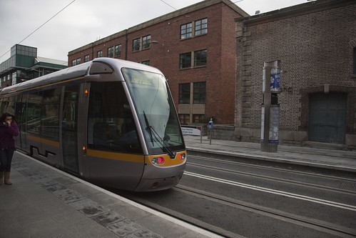
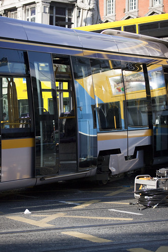
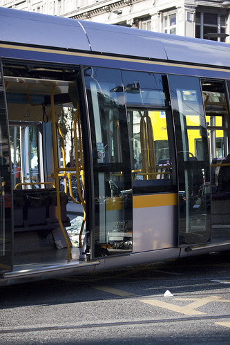
LUAS
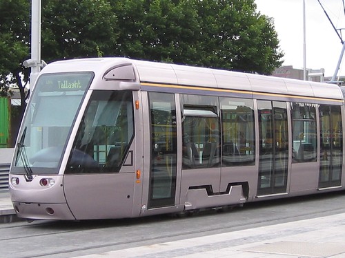
The sleek silver Citadis trams, manufactured by Alstom, reach a top speed of 70 km/h on off-road sections, but travel at a slower speed where conflicts with other vehicles or pedestrians can occur. Red Line trams, at 30 m with a capacity of 235, are shorter than the 40 m Green Line trams, which have a capacity 358 including two wheelchairs.
In other aspects, the two lines are identical except that the clearance between the lines on the Green Line is slightly wider than on the Red Line. This will allow wider metro trains be run on the same tracks if a proposed upgrade to full metro service is implemented. This is possible because the route uses an old railway line and as such has few interactions with vehicular or pedestrian traffic. The Red Line was constructed largely on or beside public roads and is not suited to wider and faster metro trains.
The main engineering structures on the Green Line at present are Milltown Viaduct, also known as The Nine Arches, a large stone viaduct dating from 1854, and the William Dargan Bridge, a large new cable-stayed suspension bridge at Taney Cross, near Dundrum town centre.
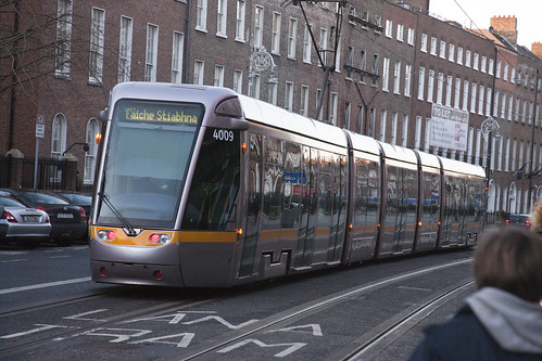
Luas Tram - George's Quay (new stop)
A new $133m (€90m) extension of Dublin's Luas tram's Red Line from Busáras to The Point has opened in Ireland.
The 1.5km light rail line serves the city's Docklands area with stops at George's Dock, Mayor Square, Spencer Dock and The Point and is the first addition to the city's tram line since it opened in 2004.
LUAS TRAM SYSTEM: 2011 fatal collision
2011 fatal collision
At 16:20 on 11 October 2011, a 35-year-old man died after being struck by a Luas red-line tram on Steeven's Lane near Heuston Station. The Luas service was stopped between the Heuston and The Point stops for 3 hours, trams between Tallaght and Blackhorse remained running throughout this period. Trams began running between Heuston and The Point again at 19:20. This was the second death involving the Luas since it began operating in 2004.
LUAS TRAM SYSTEM: 2004 Until Now
By November 2006, over 50 million journeys had been made on the system.
Around 90,000 Luas trips are made each day. 28.4 million journeys were made in 2007.[10] 27.4 million journeys were made in 2008.25.4 million journeys were made in 2009.[12] To date, the busiest day on the Luas system was Friday, 21 December 2007 when 145,000 passenger journeys were recorded.
Luas operates without a state subvention. The service recorded a surplus of €985,000 (€680,000 in 2004) - an achievement well ahead of an anticipated deficit of €2.5 million.
On the 8 December 2009 the Red Line C1 Connolly to Docklands extension opened.There are 4 stops: George's Dock, Mayor Square, Spencer Dock (serving the new Docklands railway station, approximately 500m away) and terminating in Point Village, opposite the The O2 [this extension however bypasses Connolly]. Construction started at the beginning of June 2007. Test runs began on the line in September 2009 before the opening.
The Railway Procurement Agency noted in their annual report that passenger numbers fell for the first time in 2009. The Luas had 25.4m passengers in 2009.
In June 2010, plans to join the two Luas tracks were finalised. On 20 May 2011 the Dublin City Council made submissions to An Bord Pleanála's Oral Hearing into Line BXD stating that the Planning Authority had a serious area of concern with the overhead conductor system in the historical city center asking for a wire free zone.
Luas Tram Crashes Into Bus - O'Connell Street Dublin
21 people injured (3 seriously) when a tram crashes into a number 16 bus just outside Easons on O'Connell Street.
Extract From Wikipedia:
Before the Luas was launched a Safety Awareness Day was held in Dublin City Centre. Also thousands of reflective armbands were distributed to pedestrians and cyclists, in order to ensure their visibility for tram drivers. This policy seems to have worked as the Luas has been described as being "one of the safest transport systems in the world". Both trams and stops are monitored using CCTV 24 hours a day from the central control room, located in the Red Cow Depot. The first fatality following an accident on the Luas was in February 2008, after a man was struck by a tram in Tallaght. Apart from this there have been many occurrences of cars striking trams, mainly caused by motorists breaking red lights. On the 16th of September 2009, a Luas crashed into a Dublin Bus on the O'Connell Street-Abbey Street Junction.
LUSA TRAM SYSTEM - LAUNCH OF SERVICE WAS DELAYED
The original launch date for the Luas was to be 2003, but delays in construction saw this date pushed back by a year.
An advertising campaign took place to inform the public of the development of the system, while construction was taking place. Construction finished in February 2004 and a period of testing and driver training began. 30 June 2004 was decided on as the official launch date of the Green Line.
The first tram went into service for the general public at 3 p.m. Several days of free ridership and a family fun weekend took place to launch the system. The Red Line opened on 26 September 2004, with six days of free travel for the general public.
LUAS Tram System In Dublin (Ireland)
Luas , also promoted in the development stage as the Dublin Light Rail System, is a tram or light rail system serving Dublin, the first such system in the decades since the closure of the last of the Dublin tramways. In 2007, the system carried 28.4 million passengers, a growth of 10% since 2006.
There are currently two Luas main lines. The Green line commenced operations on 30 June 2004, while the Red Line opened on 26 September 2004. But since the initial opening both lines have been extended and 'split' into different branches. As of July 2011, the system has 54 stations and 38.2 kilometres (23.7 mi) of track.
The Luas is operated by Veolia Transport, under tender from the Railway Procurement Agency (RPA). It is a major part of the Dublin Transportation Office's strategy (2000–2016).There are several extensions as well as new lines at the planning stage.
Luas Tram Crashes Into Bus - O'Connell Street Dublin
Extract From Wikipedia:
Before the Luas was launched a Safety Awareness Day was held in Dublin City Centre. Also thousands of reflective armbands were distributed to pedestrians and cyclists, in order to ensure their visibility for tram drivers. This policy seems to have worked as the Luas has been described as being "one of the safest transport systems in the world". Both trams and stops are monitored using CCTV 24 hours a day from the central control room, located in the Red Cow Depot. The first fatality following an accident on the Luas was in February 2008, after a man was struck by a tram in Tallaght. Apart from this there have been many occurrences of cars striking trams, mainly caused by motorists breaking red lights. On the 16th of September 2009, a Luas crashed into a Dublin Bus on the O'Connell Street-Abbey Street Junction.
Wednesday, December 19, 2012
Thrams In Ghent (Belgium) - Tickets
The Gent tram is operated by De Lijn (the company which provides transport service in the whole of Flanders); the fare control system is the same as on all public transport in Flanders, and there are no turnstiles. A passenger should stamp a ticket in a validator in the tram (near the doors) at the start of a journey.
A ticket, which allows an hour's travel over most of the city, costs €2 if bought from a tram-driver or €1.20 if bought in advance. Tickets are sold by vending machines at many tram stops, and at special "Lijnwinkel" kiosks (which also sell monthly and weekly passes). Tickets can also be bought at newspaper kiosks. If there is a vending machine at a tram stop, it is prohibited to buy a ticket from a driver. There are no conductors on trams, but sometimes tickets are checked by fare enforcers; travellers without tickets may be fined up to €600.
On PCC trams, the front door works only for entry; on newer HermeLijn trams passengers can enter or exit trams using any of the doors.
Trams in Ghent - Stops
History Of Trams in Ghent (Belgium)
Horse-drawn trams appeared in Gent in 1874. The rolling stock consisted of 43 carriages, 14 of them open and the other 29 closed, with 100 horses used to draw them. The horse-drawn trams were operated by Les Tramways de la Ville de Gand, which existed until 1897.
On August 13 of 1897 operating concessions were issued to the Société Anonyme des Railways Éonomiques de Liège-Seraing et Extensions (RELSE) and the Compagnie Générale des Railways à voie étroite (CGR). These companies merged on January 4, 1898 to form the SA des Tramways Electriques de Gand. The aim of this move was to replace horses by electric traction, as well as the further usage of the tram network. It was also decided to use battery-powered trams, since they did not require unsightly overhead lines.
The power of battery operated trams was 25 hp. Each tram carried 45 passengers. The maximum speed of each was 12 km/h; by law, the operator was not allowed to travel any faster. A special 600 kW generating station was built to charge the batteries of these trams.
However, battery traction was operationally unsuccessful, so in 1903 a decision was made to install overhead electrification. The first trams powered by overhead lines entered service in 1904. This date marks the birth of a tramway in Gent. From 1904 to 1961 the system was operated by "Tramway Electriques de Gand" (TEG).
During the process of electrification, the rail gauge size was reduced from 1435 mm to 1000 mm.
In the 1960s the tram network of Gent decreased rapidly, there were eleven routes (1-10, 20) in 1961. By 1974 there were just four; the route to Melle closed on New Year's Eve, 1973.
In 1961 the tram property was transferred from the TEG Tramway Electriques de Gand to the MIVG (Maatschappij voor Intercommunaal Vervoer te Gent) municipal organization.
Until 1974 the archaic two/three-axle trams "de oude gele tramkes" (old little yellow trams) were used on Gent's tram network. During their working life, they were rebuilt and refurbished several times.
Plans for a Premetro were made in the 1970s but were abandoned.
In 1989 the trolleybus operated along the former tram route 3. In June 2009, the trolleybus stopped running, and under the Pegasusplan the route will revert to tram operation.
In 1991, the MIVG tram undertaking became part of De Lijn.
In the 1990s Gent's tram system started to expand again. In 1993 route 21 was extended to Melle Leeuw.
In 1999, routes 21/22 were extended from Sint-Pieters to Zwijnaardebrug, near the E40 motorway; a further extension to Zwijnaarde-Dorp south of the E40 is scheduled to open in 2012. The last extension to the network (to date) took place on April 15, 2005, when route 1 was extended to the Flanders Expo complex.
Starting in 1998, the modernization of Gent PCC trams took place, this modernization featured the completely new interior, separate driver's cab, and better air conditioning equipment.
Since 2000, the Gent tram network started to receive new generation Low Floor tram stock, these trams were named HermeLijn (a pun on the Dutch word for ermine). Prior to this, such trams were supplied in Antwerp. Unlike Antwerp, PCC trams used in Gent are double-ended. HermeLijn in Gent, of the first order have serial number 6301 — 6314. In 2005 another order of 17 HermeLijn trams arrived in Gent (6315 — 6331). Another ten arrived in 2007 (6332 - 6341).
: A Euro PCC tram operating route 4")
Belgium: Trams in Ghent
The Ghent tramway network is part of the public transport system in the city of Ghent, Belgium, with a total of three lines (1, 21/22 and 4). Since 1991, it has been operated by De Lijn, the public transport entity responsible for buses and trams in Flanders.
As of the end of 2008, there were 40 HermeLijn trams and 43 PCC trams, running on three routes.
 |
| Photograph By: Maksim |
General description


, tram stop Henegouwenstraat in Ostend.")
The Coast Tram (Dutch: De Kusttram)
History
Characteristics

The service makes 70 stops along the 68 km long line, with a tram running every ten minutes during the peak summer months (every 20 mins in the winter months), during which it is used by over 3 million passengers. The service has recently been made more accessible through the addition of low-floor centre sections to existing vehicles, and the introduction of a few new HermeLijn low-floor trams. While most of the older trams are unidirectional, and thus have to be turned on a loop in order to reverse direction, the newer ones are bi-directional, with driving positions and doors on both end/sides. An interesting feature is the two alternative routes that exist around either end of the Leopoldkanaal locks just east of Zeebrugge, and the similar single track diversion around the inland end of the Boudewijnkanaal lock. This avoids delays to the tram schedule when the road bridge that the tram line normally follows is raised for boats passing under it. A similar feature exists at the southern end of Ostend station around the lock entrance to the Vlotdok.
 is a public transport service connecting the cities and towns along the entire Belgian (West Flanders) coast, between De Panne near the French border and Knokke-Heist")
")
Austria: Trams
The cars have been constantly modernised over the years and many are now ultra low-floored. Many of the Austrian tramlines have been in constant operation since they were first opened. Vienna started with horse trams in 1865 with electrification in 1897. Graz had horse trams in 1878 and electric cars in 1898 while Linz goes back to 1880 with electrification in 1897.
The Gmunden Tramway, only 2.3 km long, is currently one of the shortest in the world. With gradients of up to 9.6%, it is also one of the steepest and has become a popular tourist attraction.
Innsbruck, which traditionally used second-hand trams from other cities, has recently replaced its whole fleet with 32 Bombardier low-floor cars (as of Summer 2009). The Pöstlingbergbahn, in Linz, is an unusual "mountain tramway", which has a gradient of 10.6% [one of the world's steepest gradients on a surviving adhesion-only railway] and now reaches the city centre via the tracks of the urban tram system.
")


Trams in Europe
Europe has an extensive number of tramway networks. Some of these networks have been upgraded to light rail standards, called Stadtbahn in Germany, premetros in Belgium, sneltram in the Netherlands, and fast trams in some other countries.
