Showing posts with label Transport. Show all posts

Thursday, December 20, 2012

The Brussels Tram System


Intermodal integration

The system exists in an interesting local government context, because Brussels is a self-governing region, in fact an enclave within Flanders, although lying only some 3.3 kilometres from Wallonia at the closest point. This means that three-way deals are necessary between Brussels’ own STIB/MIVB, Flanders’ De Lijn and Wallonia’s TEC. Within the range of transport modes operated by STIB/MIVB (the Brussels Intercommunal Transport Company) trams fall between buses and a heavy metro. But beyond that, STIB sees itself as a provider of mobility rather than just public transport, and has a 49% share in the town’s Cambio car sharing franchise. 

The Brussels conurbation – its 19 municipalities plus adjoining commuter belt – is also served by a fairly dense network of main-line trains. There is a good level of interticketing, and multiple-journey cards are interchangeable. A simple tariff system permits passengers to make unlimited changes with a one-hour period at a cost of €2.50 when bought from the driver or €2.00 when bought from a ticket machine.
Ridership has been rising, and other user-friendly features that have grown up through custom and practice help this. For instance passengers open the doors themselves by pressing a green strip on the central pole, and drivers usually make a point of waiting for latecomers. However overcrowding at rush hours and at weekend is common, and fare-dodging is reputedly quite high, despite periodic enforcement campaigns.

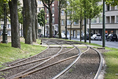
Brussels - Tram system (Route 19)

Brussels - Tram system by infomatique
Brussels - Tram system, a photo by infomatique on Flickr.
The tram route 19 in Brussels, Belgium is a tram route operated by the STIB/MIVB, which connects the Flemish town of Groot-Bijgaarden in the municipality of Dilbeek to the De Wand stop in Laeken in the municipality of the City of Brussels.

Starting from the Groot-Bijgaarden railway station in Dilbeek, the route then stops at the Bayens roundabout and then enters the Brussels-Capital Region via the Brusselstraat. The first stop in Brussels is at Hunderenveld in the municipality of Sint-Agatha-Berchem. The route then runs along the Avenue du Roi Albert/Koning Albertlaan up to the Dr. Schweitzer square, the Avenue Josse Goffin/Josse Goffinlaan and the Avenue de l'Hôpital Français/Frans Gasthuislaan where it enters the municipality of Koekelberg. The route then runs along the Basilica of the Sacred Heart and the Elisabeth park on the Avenue du Panthéon/Pantheonlaan and then on the Avenue de la Liberté/Vrijheidslaan up to the Simonis metro station. At Simonis the route turns left on the Avenue de Jette/Jetselaan and then enters the municipality of Jette. At the Queen Astrid square the route heads towards the Jette railway station via the Rue Léon Théodor/Léon Théodorstraat, then runs around the Jette cemetary via the Rue Jules Lahaye/Jules Lahayestraat and enters the Boulevard de Smet de Naeyer/De Smet de Naeyerlaan. Further on this boulevard, the route enters the borough of Laeken in the City of Brussels and then connects again with the Brussels Metro at the Stuyvenbergh metro station. The route finally runs along the Avenue des Robiniers/Witte Acacialaan and Avenue Jean Sobieski/Jan Sobieskilaan and then crosses the Laeken park by entering a tunnel which ends at the other end of the Laeken park at the De Wand stop.

LUSA TRAM SYSTEM - LAUNCH OF SERVICE WAS DELAYED


The original launch date for the Luas was to be 2003, but delays in construction saw this date pushed back by a year.

An advertising campaign took place to inform the public of the development of the system, while construction was taking place. Construction finished in February 2004 and a period of testing and driver training began. 30 June 2004 was decided on as the official launch date of the Green Line.

The first tram went into service for the general public at 3 p.m. Several days of free ridership and a family fun weekend took place to launch the system. The Red Line opened on 26 September 2004, with six days of free travel for the general public.

Wednesday, December 19, 2012

Belgium: Trams in Ghent


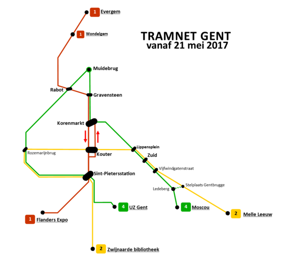
The Ghent tramway network is part of the public transport system in the city of Ghent, Belgium, with a total of three lines (1, 21/22 and 4). Since 1991, it has been operated by De Lijn, the public transport entity responsible for buses and trams in Flanders.

As of the end of 2008, there were 40 HermeLijn trams and 43 PCC trams, running on three routes.


Belgium: Trams in Ghent - Route Map
Photograph By: Maksim

General description


The network covers approximately 30 kilometers. The rail gauge is 1000 mm and trams are powered by 600V DC overhead wires. The network uses dedicated rights of way as well as mixed traffic; the right of way on Groot-Britanniëlaan is shared with by buses.
The system used to have one short tunnel, around 150 meters long, passing underneath Sint-Pieters railway station.The Sint-Pieters Station tram stop was located inside the tunnel. It was opened on June 28, 1996.

The system has no triangles and only a single turnback loop. Therefore, all rolling-stock must be bidirectional, with cabs at each end. There are also two non-switch 90-degree crossings, between the lines of routes 1 and 21/22, on the crossing of Zonnestraat with Veldstraat as well as Korte Meers street. There are two crossings because the track of route 1 passes over streets in each direction. Along the Korte Meer the tram track goes toward the city center, the Korenmarkt stop, yet returns along the pedestrian/tram-only shopping area along the Veldstraat.

On streets where tram tracks are located away from the sidewalk, i.e. in the middle of the roadway, stops are located on islands with pedestrian overpasses leading to them. This improves pedestrian safety.