Showing posts with label Belgium. Show all posts

Thursday, December 20, 2012

Brussels Tram (Video Clip)

The Brussels tram (or streetcar) system is a successful medium-sized system, whose development demonstrates many of the quandaries that face local public transport planners. It also has a number of interesting peculiarities.

There are 17 routes, serving most points of the compass, and including two partial ring routes. These have a very varied feel, including street running through narrow streets in working class districts (lines 81 and 82), cobbled central reservation, reserved track through parkland and woods (44), and signal-controlled running in tunnels (the "premetro"). There are even some short stretches of gutter running (18). Almost all trams are double-ended and all are double-sided, and some stub termini in the middle of the road remain (55), although most have loops. The route pattern shows some notable gaps, particularly along major radial routes, because these were originally served by a separate tram system, the national network of tramways vicinaux/buurtspoorwegen. These had a track gauge of one metre, as against the Brussels standard gauge, and so the tracks could not easily be taken over when the lines were progressively closed from the 1960s onwards.
The complementary routing of vicinal and urban tracks and the replacement of key lines by metro has led to some peculiar track layouts, for instance at the Barrière de St-Gilles/Bareel St-Gillis. Of the seven roads that meet at this circular junction, six originally contained tramlines, whereas today only three do. To negotiate a sharp turn, route 18, until it was closed on 1 July 2007, had to make a 270-degree turn on its journey away from the city centre, looping round and crossing its own path.
A further peculiarity is that under the South station, the premetro and metro tracks both swap from running on the right to running on the left where they run parallel to provide cross-platform interchange between the two lines. This serves no apparent purpose, but may be because main line trains in Belgium run on the left. The metro returns to running on the right under the new Jacques Brel depot.
Between 2006 and 2009 a phased transformation of the tram network took place, with the aim of improving regularity and relieving overcrowding. As part of this the premetro service between North station and Albert was restructured with fewer lines passing through it, but at more regular intervals. These routes use the new longer Bombardier trams. During this period of transformation the bus network underwent complementary revisions.

The Brussels Tram System


Intermodal integration

The system exists in an interesting local government context, because Brussels is a self-governing region, in fact an enclave within Flanders, although lying only some 3.3 kilometres from Wallonia at the closest point. This means that three-way deals are necessary between Brussels’ own STIB/MIVB, Flanders’ De Lijn and Wallonia’s TEC. Within the range of transport modes operated by STIB/MIVB (the Brussels Intercommunal Transport Company) trams fall between buses and a heavy metro. But beyond that, STIB sees itself as a provider of mobility rather than just public transport, and has a 49% share in the town’s Cambio car sharing franchise. 

The Brussels conurbation – its 19 municipalities plus adjoining commuter belt – is also served by a fairly dense network of main-line trains. There is a good level of interticketing, and multiple-journey cards are interchangeable. A simple tariff system permits passengers to make unlimited changes with a one-hour period at a cost of €2.50 when bought from the driver or €2.00 when bought from a ticket machine.
Ridership has been rising, and other user-friendly features that have grown up through custom and practice help this. For instance passengers open the doors themselves by pressing a green strip on the central pole, and drivers usually make a point of waiting for latecomers. However overcrowding at rush hours and at weekend is common, and fare-dodging is reputedly quite high, despite periodic enforcement campaigns.


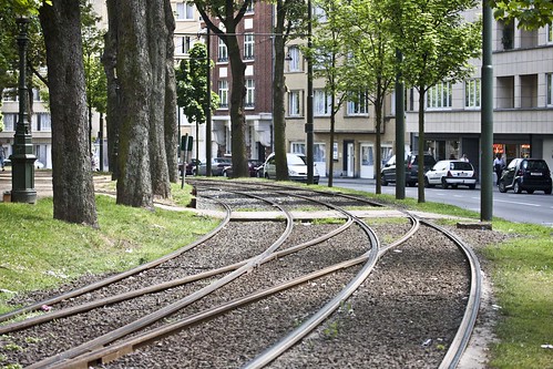
Brussels - Tram system (Route 19)

Brussels - Tram system by infomatique
Brussels - Tram system, a photo by infomatique on Flickr.
The tram route 19 in Brussels, Belgium is a tram route operated by the STIB/MIVB, which connects the Flemish town of Groot-Bijgaarden in the municipality of Dilbeek to the De Wand stop in Laeken in the municipality of the City of Brussels.

Starting from the Groot-Bijgaarden railway station in Dilbeek, the route then stops at the Bayens roundabout and then enters the Brussels-Capital Region via the Brusselstraat. The first stop in Brussels is at Hunderenveld in the municipality of Sint-Agatha-Berchem. The route then runs along the Avenue du Roi Albert/Koning Albertlaan up to the Dr. Schweitzer square, the Avenue Josse Goffin/Josse Goffinlaan and the Avenue de l'Hôpital Français/Frans Gasthuislaan where it enters the municipality of Koekelberg. The route then runs along the Basilica of the Sacred Heart and the Elisabeth park on the Avenue du Panthéon/Pantheonlaan and then on the Avenue de la Liberté/Vrijheidslaan up to the Simonis metro station. At Simonis the route turns left on the Avenue de Jette/Jetselaan and then enters the municipality of Jette. At the Queen Astrid square the route heads towards the Jette railway station via the Rue Léon Théodor/Léon Théodorstraat, then runs around the Jette cemetary via the Rue Jules Lahaye/Jules Lahayestraat and enters the Boulevard de Smet de Naeyer/De Smet de Naeyerlaan. Further on this boulevard, the route enters the borough of Laeken in the City of Brussels and then connects again with the Brussels Metro at the Stuyvenbergh metro station. The route finally runs along the Avenue des Robiniers/Witte Acacialaan and Avenue Jean Sobieski/Jan Sobieskilaan and then crosses the Laeken park by entering a tunnel which ends at the other end of the Laeken park at the De Wand stop.

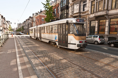
No. 92 Tram - Brussels

No. 92 Tram - Brussels by infomatique
No. 92 Tram - Brussels, a photo by infomatique on Flickr.
There are 17 routes, serving most points of the compass, and including two partial ring routes. These have a very varied feel, including street running through narrow streets in working class districts (lines 81 and 82), cobbled central reservation, reserved track through parkland and woods (44), and signal-controlled running in tunnels (the "premetro"). There are even some short stretches of gutter running (18). Almost all trams are double-ended and all are double-sided, and some stub termini remain (4, 55), although most have loops. The route pattern shows some notable gaps, particularly along major radial routes, because these were originally served by a separate tram system, the national network of buurtspoorwegen/tramways vicinaux. These had a track gauge of one metre, as against the Brussels standard gauge, and so the tracks could not easily be taken over when the lines were progressively closed from the 1960s onwards.

The complementary routing of vicinal and urban tracks and the replacement of key lines by metro has led to some peculiar track layouts, for instance at the Barrière de St-Gilles/Bareel St-Gillis. Of the seven roads that meet at this circular junction, all originally contained tramlines, whereas today only three do. To negotiate a sharp turn, route 18, until it was closed on 1 July 2007, had to make a 270-degree turn on its journey away from the city centre, looping round and crossing its own path.

A further peculiarity is that under the South station, the premetro and metro tracks both swap from running on the right to running on the left where they run parallel to provide cross-platform interchange between the two lines. This serves no apparent purpose, but may be because main line trains in Belgium run on the left. The metro returns to running on the right under the new Jacques Brel depot.

Between 2006 and 2009 a phased transformation of the tram network took place, with the aim of improving regularity and relieving overcrowding. As part of this the premetro service between North station and Albert was restructured with fewer lines passing through it, but at more regular intervals. These routes use the new longer Bombardier trams. The major part of the North-South Axis (from Lemonnier to Rogier) is now only used by lines 3 and 4 during the day. Tram lines 55 and 56 from Schaerbeek (north of Brussels) that used to ride the North-South Axis now stop at Rogier and nearby Gare du Nord/Noordstation.

As part of that plan, line 52 has been replaced by line 3 in the North (from the Brussels-South railway station to Thomas and from Van Praet to Esplanade), and by lines 56 (from Rogier to Princess Elisabeth), 82 (from Drogenbos to Lemonnier) and 32 in the South.

An already implemented part of this plan is the creation of tramway lines 24 and 25. Since April 2007 the new line 25 goes from Rogier to the Boondael/Boondaal railway station following the route of the ex-line 90 from Rogier to Buyl, then leaves the outer ring towards the Université Libre de Bruxelles campus of Solbosch. The (somewhat older) new line 24 strengthens the tram presence on the outer ring during daytime; it goes from the Schaerbeek/Schaarbeek railway station to Vanderkindere in Uccle.

en.wikipedia.org/wiki/Brussels_trams

Wednesday, December 19, 2012

Thrams In Ghent (Belgium) - Tickets


The Gent tram is operated by De Lijn (the company which provides transport service in the whole of Flanders); the fare control system is the same as on all public transport in Flanders, and there are no turnstiles. A passenger should stamp a ticket in a validator in the tram (near the doors) at the start of a journey.

A ticket, which allows an hour's travel over most of the city, costs €2 if bought from a tram-driver or €1.20 if bought in advance. Tickets are sold by vending machines at many tram stops, and at special "Lijnwinkel" kiosks (which also sell monthly and weekly passes). Tickets can also be bought at newspaper kiosks. If there is a vending machine at a tram stop, it is prohibited to buy a ticket from a driver. There are no conductors on trams, but sometimes tickets are checked by fare enforcers; travellers without tickets may be fined up to €600.

On PCC trams, the front door works only for entry; on newer HermeLijn trams passengers can enter or exit trams using any of the doors.

Belgium: Trams in Ghent


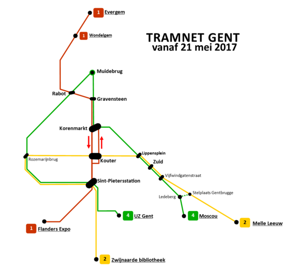
The Ghent tramway network is part of the public transport system in the city of Ghent, Belgium, with a total of three lines (1, 21/22 and 4). Since 1991, it has been operated by De Lijn, the public transport entity responsible for buses and trams in Flanders.

As of the end of 2008, there were 40 HermeLijn trams and 43 PCC trams, running on three routes.


Belgium: Trams in Ghent - Route Map
Photograph By: Maksim

General description


The network covers approximately 30 kilometers. The rail gauge is 1000 mm and trams are powered by 600V DC overhead wires. The network uses dedicated rights of way as well as mixed traffic; the right of way on Groot-Britanniëlaan is shared with by buses.
The system used to have one short tunnel, around 150 meters long, passing underneath Sint-Pieters railway station.The Sint-Pieters Station tram stop was located inside the tunnel. It was opened on June 28, 1996.

The system has no triangles and only a single turnback loop. Therefore, all rolling-stock must be bidirectional, with cabs at each end. There are also two non-switch 90-degree crossings, between the lines of routes 1 and 21/22, on the crossing of Zonnestraat with Veldstraat as well as Korte Meers street. There are two crossings because the track of route 1 passes over streets in each direction. Along the Korte Meer the tram track goes toward the city center, the Korenmarkt stop, yet returns along the pedestrian/tram-only shopping area along the Veldstraat.

On streets where tram tracks are located away from the sidewalk, i.e. in the middle of the roadway, stops are located on islands with pedestrian overpasses leading to them. This improves pedestrian safety.

The Coast Tram (Dutch: De Kusttram)

The Coast Tram (Dutch: De Kusttram) is a public transport service connecting the cities and towns along the entire Belgian (West Flanders) coast, between De Panne near the French border andKnokke-Heist. At 68 km (42 miles) in length, it is the longest tram line in the world, as well as one of the few interurban tramways in the world to remain in operation. The line is built atmetre gauge and fully electrified at 600 V d.c.


History

The first section of the track between Oostende and Nieuwpoort was brought into service in 1885, although the original route was further inland than the modern one and only short sections in Oostende and Nieuwpoort centres are still in operation. On its creation, the line was managed by the NMVB (National Neighbourhood Railway Company). In 1991, the NMVB/SNCV was broken into two regional companies, one Walloon and the other Flemish, with the Flemish successor company, Vlaamse Vervoermaatschappij De Lijn taking responsibility for operation of the coastal tram.

Characteristics


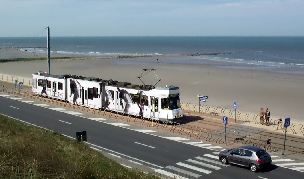
The Belgian Coast Tram near Ostend


The service makes 70 stops along the 68 km long line, with a tram running every ten minutes during the peak summer months (every 20 mins in the winter months), during which it is used by over 3 million passengers. The service has recently been made more accessible through the addition of low-floor centre sections to existing vehicles, and the introduction of a few new HermeLijn low-floor trams. While most of the older trams are unidirectional, and thus have to be turned on a loop in order to reverse direction, the newer ones are bi-directional, with driving positions and doors on both end/sides. An interesting feature is the two alternative routes that exist around either end of the Leopoldkanaal locks just east of Zeebrugge, and the similar single track diversion around the inland end of the Boudewijnkanaal lock. This avoids delays to the tram schedule when the road bridge that the tram line normally follows is raised for boats passing under it. A similar feature exists at the southern end of Ostend station around the lock entrance to the Vlotdok.

The Belgian Coast Tram near Ostend

Coast Tram (Belgium)